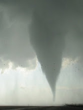
The usual cold core goldmine of SW KS is producing again... with 6+ tor reports in the DDC area including reports of two on the ground at once. I finished a string of five midnight shifts at 7 A.M. and wish I had looked closer at this potential target and considered trying to chase after work, rather than driving home and crashing for some much needed sleep... but that's fatigue for ya.
The set-up fits the classic Jon Davies pattern pretty well, though the low-level pressure/height field (and thus low-level shear) is very weak. Cells fired first near the intersection of the slow-moving occluded front and a weakly defined west-to-east boundary... then built southsoutheastward along the occluded front. Only the cells near the subtle boundary intersection and/or just to the cool side of the west-to-east boundary have been tornadic. While ambient horizontal and vertical vorticity associated with the boundary intersection and mid-level low are probably playing a role, low-level stretching--associated with steep low- thru mid-level lapse rates and very large low-level instability--are probably dominating w.r.t. tornadogenesis processes. The 12Z DDC sounding this morning sampled 700mb and 500mb temps of -5°C and -25°C respectively... more typical of a late winter cold core set-up (though low-level theta-e is modest, an offsetting factor). Had I seen that 12Z sounding before going to sleep, I may have reconsidered whether to chase.
Anyway, big kudos for John Hart & SPC for going with a tor box on this one in spite of very marginal low-level flow/shear!
Saturday, April 18, 2009
Subscribe to:
Post Comments (Atom)

No comments:
Post a Comment