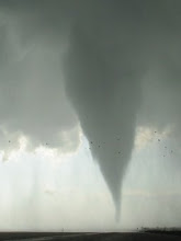
We moved as far west as Sedan KS 3-4 PM, letting a few marginally impressive severe storms trail by well to our west. We gradually moved east, staying near Highway 166 to keep our options open. With nothing really becoming dominant and with storms farther south largely taking a linear configuration, things were looking a bit grim as we reached Edna KS around 545 PM. Suddenly, a semi-discrete and intensifying storm along the OK turnpike caught our eye. Moments later it received a tor-warning, and that sealed it--we headed farther east on 166 for an intercept. Given the torrential rain and getting caught behind a semi... it took us longer to get there than it should have.
Eerily, we intercepted the storm in the town of Picher OK (struck by a killer EF-4 tornado in May 2008), with tornado sirens blazing as cityfolk looked warily off to the SW to try to catch a glimpse of the storm. The supercell was in the process of rapidly contracting, and completely dissolved not 15 minutes later. We got a good look at the compact rainfree base (and a couple nub funnels... see pix below, view looking south at 6:37 PM) before it wrapped in rain. Lots of dime hail, with maybe a few quarters, in the core... impressive considering the storm was going downhill so quickly. Interesting that an EM reported a tornado near Miami only a couple minutes prior to our close intercept of the base, but concensus from numerous chaser/public videos is that the funnel cloud in question did not touch down.
Significant tornadoes managed to occur farther south in the Mena AR and Shreveport LA areas. It's possible that the environment was more strongly surface-based in a wider corridor in those areas due to stronger moisture return. Clearly, had our dewpoints been 5°F higher across the board, tornado potential would have increased considerably. There also may have been a few problems with the local shear profile in northeast OK/far southeast KS (e.g. initially modest 0-1 km SRH, or a veering-backing pattern in the vertical), but wind profiler data wasn't much help in conclusively gauging that one way or another.
As for the cold core target along the trailing surface trough/psuedo-occluded front, surface dewpoints appeared to verify about 2°F lower than forecast from the 12Z NAM and as much as 4°F lower than from the 12Z RUC. Given the related LCL heights and 0-3 km CAPE had been forecast to be only modestly favorable to the cool side of the front, I can only assume that the parameters took a further hit given the poorer-than-forecast moisture. Pressure rises in the wake of the primary surface low, with the wind shift pushing southward as a cold front, may have also acted to minimize the width and/or duration of the unstable boundary layer along and N of the front... if not undercutting updrafts altogether. The 00Z/12Z NAM and 09Z/12Z RUC did a good job with forecasting the evolution of this surface boundary, despite my having worried that the southward push from the NAM was a result of modeled cold pooling associated with very vigorous convective initiation forecast along the boundary. The progressive easterly motion of the mid-level low not far behind the surface low, also noted by Dick, probably had a role in the isallobaric forcing and frontal evolution. In the loose analog case of 10-26-06, the cyclone did not appear to be as vertically stacked, probably favoring the more stationary nature of the occluded boundary.


1 comment:
Great account, I hate recalling chase accounts unless it was a superb day. Good seeing you again, see you in May most likely LOL.
Dick
Post a Comment