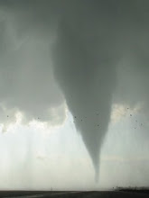
The potential for a tornado event across portions of north Texas on Monday is increasing based on the latest model guidance.
The ECMWF has been very consistent the past several days in its handling of a seasonably potent shortwave trough that is currently moving onshore from the Pacific... forecasting amplification through the southern Rockies and into the southern plains, and mass response/backed low-level flow contributing to large hodographs and deep moisture for potentially significant surface-based severe storms late on Monday. Meanwhile, the GFS has ben rather inconsistent from run-to-run, and generally has forecast the ejection of a more progressive and positive-tilt upper system--less favorable for tornadoes.
The jet energy on the back side of the trough is nearly fully onshore this morning and thus sampled in part by the northern CA RAOBs... and the 12Z NAM-WRF model is in very close agreement to the solution offered by the ECMWF the past several days. As a result, my forecast will closely follow the high-res NAM-WRF guidance. The 12Z GFS has suddenly trended in the direction of the ECMWF and NAM, but remains a little less potent with regard to tornado potential. Accordingly, this evening's obs and guidance will be monitored closely for last-minute trends.
Water vapor imagery attm shows the strong upper trough digging toward the lower CO river valley, with a downstream 500 mb 12-hr height fall center of 200 m attesting to the strength of this feature. Modified gulf moisture, with surface dewpoints of 63-65F, is already returning over deep south Texas and adjacent portions of Mexico as pressures fall in the lee of the Rockies. This moisture is favorably deep, with a nearly 2 km deep moist layer sampled on the ADN RAOB (west of BRO)!
Vertical motion associated with a significant lead impulse will enhance isentropic lift and moisture transport atop a stable near-surface layer late tonight, resulting in showers and thunderstorms across the eastern TX panhandle, northwestern TX, and western OK through the mid-morning hours. The majority of this convection may end up staying primarily north of the ultimate target area for surface-based storms later on Monday.
In the wake of this convection, a favorably timed and subsident mid-level dryslot will overspread the eastern TX south plains and adjacent northwestern TX by early afternoon. Downward transfer of westerly momentum will gradually sharpen the dryline as it mixes to near a Childress to Sweetwater line during the afternoon. A couple of discrete supercells should initiate and develop on or ahead of the dryline by 4-5 PM as significant ascent with the primary shortwave trough rotates across the area.
Ahead of the dryline, dewpoints of 60-64F should materialize in the wake of the warm front via northward advection and downward mixing. With strong heating expected in at least a narrow corridor, MLCAPE of 1000-2000 J/kg is expected in the warm sector. Low-level thermodynamics are forecast to be quite favorable for tornadoes, with modest T/Td spreads (low LCLs) and "cool" thermal profiles above the boundary layer (strong low-level CAPE). Meanwhile, mid-and high-level flow will certainly support significant supercells, and hopefully will not be too strong so as to overwhelm updrafts amidst moderate instability. Low-level hodographs should recover/enlarge slightly through afternoon as 30-40 kt 1 km flow backs to SSW in response to dynamic support, contributing to 0-1 km SRH of 200-300 m2/s2. The net result should be an appreciable localized tornado threat over northwestern TX ~5-9 PM, particularly if and where the warm sector is broad enough to allow storms to develop significant low-level mesocyclones before becoming elevated north/east of the surface warm front. Farther south, a tornado threat may actually persist through the night as very rich moisture influx (surface dewpoints of 65-68) helps to maintain weak inhibition well after dark.
Sunday, November 9, 2008
Subscribe to:
Post Comments (Atom)

No comments:
Post a Comment