Images at bottom of post:
18Z OKX RAOB overlaid on 12Z OKX RAOB
12Z OKX hodograph (with NYC tornadic supercell motion estimate)
18Z OKX hodograph (with NYC tornadic supercell motion estimate)
15Z high-res RAP initialized sounding at JFK with very slight near-sfc modifications as needed (26/23C at the surface; near-surface temp and to a lesser degree dew point were a bit underdone)
15Z high-res RAP initialized hodograph at JFK (with NYC tornadic supercell motion estimate)
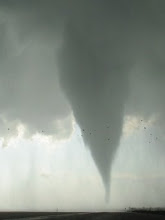
No time to dissect this event closely, but it appears as though the mid-morning roughly N-S band of storms containing the tornadic supercell initiated in an area of weak mid-level height falls well downstream of the mid- through upper-level neutral tilt large scale trough. At the time the trough was positioned over ern Ontario, Lake Huron, and lower Michigan... with the forward-side-of-trough mid- to upper-level jet axes overspreading (at best) the OH river valley and ern Great Lakes/wrn NY/swrn Que. Best (only?) correlation I can find re: an initiating mechanism, synoptic/mesoscale/sub-mesoscale, would be rather strong moisture advection occurring across a sharp low level dew point gradient. This moisture appeared to move up the border region of ern NY and CT-MA-VT with time...nearly coincident with the initiation of the batch of surface-based storms. Sfc dews on Long Island certainly jumped 4F or so between 11 and 14Z. Beyond that haven't and probly won't assess it much more from a convective initiation and maintenance standpoint.
Interestingly, the 15Z RAP sounding looks literally like an exact interpolation of the 12Z and 18Z OKX RAOBs (only with the exception of the 500 m to 3 km layer dew point; that layer is of course saturated), so confidence in this sounding's shape and character in representing the environment is quite high. Any semblance of steep mid-level lapse rates or remnant EML is lacking, yet very rich low-level moisture (lowest 100 mb ML dew points of 71F) and the 3 km deep moist layer helped contribute to moderate MLCAPE (~1500 J/kg) and no MLCIN. Also... very strong low level MLCAPE (~180 J/kg from 0-3 km AGL); and the typical "LCL = LFC" tornado-friendly environment with both being very low at ~490 m.
The shape of the near-surface hodo and associated low level SRH magnitude is anyone's guess. Surface flow in the mesoscale env was likely around 160 degrees across the board; but all the soundings shown here (the two RAOBs as well as the RAP sounding), strangely enough *especially* from the RAOBs, have surface flow that is unrealistically veered (from 180 deg or more). The strength of the sfc flow looks reasonable on the RAP sounding, while on the 18Z RAOB it is surprisingly light when compared to wrn-cntrl Long Island ASOSs. Unfortunately VWP data from the local 88D was very sparse during the event, which means making a high-res VWP hodograph to represent this tornadic supercell is impossible.
Final note... the srn-cntrl Quebec sfc low--which the sfc cold front (well upstream of the NYC tornadic storm) stemmed from--dropped all the way down to 985 mb by Saturday evening (8-9 PM local time)... 3.5+ standard deviations below climo for early Sept. This fact certainly didn't result in a large (low level) hodograph for this event mid-morning Saturday well south and east in NYC metro... but it's worth noting the parent low-level cyclone was somewhat of a whopper.
Sunday, September 9, 2012
Sunday, September 2, 2012
EHI vs. STP in Davies and Fischer 2009
Comparison of 0-1 km EHI and fixed STP (2003 version; CIN not included) from "Environmental Characteristics Associated with Nighttime Tornadoes" (Davies and Fischer 2009). This paper utilized a database of 1705 RUC proximity soundings associated with supercells east of the Rockies from 2001-2006... in order to study discrimination of thermodynamic and vertical shear parameters among the subsets of daytime non-tornadic, daytime weak tornadic, daytime sig tornadic, nighttime nontornadic, nighttime weak tornadic, and nighttime sig tornadic supercells. For brevity's sake, STP (among other discussions) had to be excluded from the paper. The STP graphic (in two "pieces" above) was hand-drawn by Jon, and while I briefly mentioned its relative discriminatory ability when presenting the paper at the 2009 NWA conference... it hasn't otherwise been seen. Click to enlarge the images. Full paper viewable at http://www.nwas.org/ej/2009-EJ3/.
Saturday, July 14, 2012
Saturday, June 9, 2012
Some soundings from 06/09/12 sfc-based convective failure in bulk of Dakotas
Above image: 23Z initialized RAP sndg at ABR overlaid on 00Z ABR RAOB. Click to see full image.
Above image: 12Z NAM-WRF sndg overlaid on 09Z NAM-KF sndg; both at ABR, valid times of both = 23Z. Click to see full image.
Subscribe to:
Posts (Atom)


