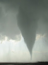
Below is the modified 18Z OUN RAOB and 21Z Purcell profiler to represent the environment of this storm as it produced an EF-2 tornado that struck Edmond, OK around 300PM. This storm fired on the northern flank of the returning deep BL moisture (another reason I'd probably have never targeted this region, all things considered), and had no trouble becoming a strong supercell producing baseball hail for a few hours. The rapidity with which the storm became such a nasty little beast is slightly surprising given very strong deep layer shear (the Purcell profiler sampled 6 km flow as high as 88 kts!!), as I usually like to see stronger low-level shear for such set-ups than was in place for this one. However, moderate CAPE was present (approaching 1500 J/kg...certainly stronger than forecast), and low-level CAPE was very strong (150 J/kg below 3 km) given seasonably cold temps above the BL... these factors probably played a role in allowing for the long-lived supercell.


Sadly, after dark, the second and final significant tornado of the day struck portions of Lone Grove, OK and caused 9 fatalities. By around sundown, the synoptic cold front was overtaking the dryline across west OK and northwest TX, encouraging upscale convective growth to a solid squall line. Convective initiation concurrently took place farther east in the warm sector, with a supercell emerging south through east of Wichita Falls, TX. Pretty much everything was in place for this storm to become a violent tornado-producer as it approached the western edge of the nocturnally-accelerating LLJ core. Even if surface temperatures had fallen toward the mid 60s after sundown in advance of this storm, the quality of the boundary layer moisture (surface dewpoints near 64°F) and absence of a significant EML would have allowed for a sufficiently strong surface-based environment to persist. As it was, surface temperatures managed to hold in the 70-72°F range in the storm's inflow environment through at least 8 P.M... resulting in the maintenance of near-zero CINH and very strong low-level instability (150-200 J/kg 0-3 km MLCAPE). In addition to the absolutely ideal low-level thermodynamic environment after dark, MLCAPE was > 2000 J/kg, with quite strong deep layer shear and 0-1 km SRH exceeding 300 m2/s2 (see modified 00Z DFW sounding and its hodograph blended with 01-02Z VWP data from the FWS 88D). The tornado was on the ground for over an hour, and preliminarily has received a rating of high-end EF-4. This case continues the unnerving trend for nighttime killer tornadoes in the Plains the past few years... more often seen in the deep South. Luckily the storm was swallowed shortly thereafter from behind by the squall line... and despite the prefrontal warm sector remaining mild and weakly capped all night, additional convective initiation did not take place there.


No comments:
Post a Comment