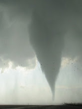
On January 30, a discrete cell moved northeastward from central AL to nwrn GA... by which time a long-lived QLCS began to "absorb it" from behind. Storm motion was 50-55 kt during this period as it gradually curved from direction ~210° to ~225°. Just about the time it was becoming absorbed by the QLCS (~1615Z) the cell spawned a rather substantial-looking tornado in and around the city of Adairsville GA. This tornado killed at least one person and overturned numerous vehicles per the LSR. WFO Peachtree City, 55nm to the SSE of the tornadic storm, launched a special RAOB about 45 minutes later...giving us a somewhat rare look at the observed environment of a tornado. A link to a short video clip of the tornado is here: http://twitter.yfrog.com/jojvyvkslexkozpdbjxdfoxcz
I modified the RAOB very slightly via cooling the near-surface layer a bit to be perhaps more representative of the inflow; while the surface wind on the RAOB looked sufficiently representative. Am not getting terribly cute regardless given some showers existed in the inflow environment.
Here are some of the parameters from the modified RAOB. Should note first, the often typical "weaker SRH" (due usually to a more veered sfc-kink shear vector and/or a weaker LLJ) NAM solution actually was more correct by comparison than the RAP solution was. Usually the RAP is the winner in this department. Also, the 2-6 km anticyclonic kink/subtle veer-back-veer pattern with height--and associated SR-flow weakness--fcst by both the NAM and the RAP...which I've found present in a good handful of observed tornadic supercell environments...was not present whatsoever via the RAOB. i.e., the cell likely had favorable SR flow at all levels. The angle between the surface to kink shear vector and the storm motion is less than 60 degrees... not atypical of many tornadoes in the ern United States--in fact the hodograph itself is quite reminiscent of some past sig tor events' observed hodographs in MS/AL/TN. And finally, the RAOB hodograph's "Bunkers right mover" fcst motion for this cell during its tornadic phase nailed the observed motion, with the direction essentially spot on and the speed very close or a touch faster than observed (not surprising given the somewhat shallow convective layer?). The storm was certainly an EL-buster based on the echo tops/visible satellite presentation.
Sfc T/Td: 68/64°F
SBCAPE: 440 J/kg
SBCIN: 12 J/kg
ML T/Td: 71/63°F
MLCAPE: 428 J/kg
MLCIN: 1 J/kg
0-3 km MLCAPE: 139 J/kg
MLLCL: 566 m
MLLFC: 669 m
0-1 km SRH: 344 m2/s2
0-3 km SRH: 495 m2/s2
0-6 km bulk shear: 75 kt
storm motion: 228° @ 53 kt
Wednesday, January 30, 2013
Sunday, September 9, 2012
estimate of 09/08/12 NYC tornado environment
Images at bottom of post:
18Z OKX RAOB overlaid on 12Z OKX RAOB
12Z OKX hodograph (with NYC tornadic supercell motion estimate)
18Z OKX hodograph (with NYC tornadic supercell motion estimate)
15Z high-res RAP initialized sounding at JFK with very slight near-sfc modifications as needed (26/23C at the surface; near-surface temp and to a lesser degree dew point were a bit underdone)
15Z high-res RAP initialized hodograph at JFK (with NYC tornadic supercell motion estimate)
No time to dissect this event closely, but it appears as though the mid-morning roughly N-S band of storms containing the tornadic supercell initiated in an area of weak mid-level height falls well downstream of the mid- through upper-level neutral tilt large scale trough. At the time the trough was positioned over ern Ontario, Lake Huron, and lower Michigan... with the forward-side-of-trough mid- to upper-level jet axes overspreading (at best) the OH river valley and ern Great Lakes/wrn NY/swrn Que. Best (only?) correlation I can find re: an initiating mechanism, synoptic/mesoscale/sub-mesoscale, would be rather strong moisture advection occurring across a sharp low level dew point gradient. This moisture appeared to move up the border region of ern NY and CT-MA-VT with time...nearly coincident with the initiation of the batch of surface-based storms. Sfc dews on Long Island certainly jumped 4F or so between 11 and 14Z. Beyond that haven't and probly won't assess it much more from a convective initiation and maintenance standpoint.
Interestingly, the 15Z RAP sounding looks literally like an exact interpolation of the 12Z and 18Z OKX RAOBs (only with the exception of the 500 m to 3 km layer dew point; that layer is of course saturated), so confidence in this sounding's shape and character in representing the environment is quite high. Any semblance of steep mid-level lapse rates or remnant EML is lacking, yet very rich low-level moisture (lowest 100 mb ML dew points of 71F) and the 3 km deep moist layer helped contribute to moderate MLCAPE (~1500 J/kg) and no MLCIN. Also... very strong low level MLCAPE (~180 J/kg from 0-3 km AGL); and the typical "LCL = LFC" tornado-friendly environment with both being very low at ~490 m.
The shape of the near-surface hodo and associated low level SRH magnitude is anyone's guess. Surface flow in the mesoscale env was likely around 160 degrees across the board; but all the soundings shown here (the two RAOBs as well as the RAP sounding), strangely enough *especially* from the RAOBs, have surface flow that is unrealistically veered (from 180 deg or more). The strength of the sfc flow looks reasonable on the RAP sounding, while on the 18Z RAOB it is surprisingly light when compared to wrn-cntrl Long Island ASOSs. Unfortunately VWP data from the local 88D was very sparse during the event, which means making a high-res VWP hodograph to represent this tornadic supercell is impossible.
Final note... the srn-cntrl Quebec sfc low--which the sfc cold front (well upstream of the NYC tornadic storm) stemmed from--dropped all the way down to 985 mb by Saturday evening (8-9 PM local time)... 3.5+ standard deviations below climo for early Sept. This fact certainly didn't result in a large (low level) hodograph for this event mid-morning Saturday well south and east in NYC metro... but it's worth noting the parent low-level cyclone was somewhat of a whopper.
18Z OKX RAOB overlaid on 12Z OKX RAOB
12Z OKX hodograph (with NYC tornadic supercell motion estimate)
18Z OKX hodograph (with NYC tornadic supercell motion estimate)
15Z high-res RAP initialized sounding at JFK with very slight near-sfc modifications as needed (26/23C at the surface; near-surface temp and to a lesser degree dew point were a bit underdone)
15Z high-res RAP initialized hodograph at JFK (with NYC tornadic supercell motion estimate)
No time to dissect this event closely, but it appears as though the mid-morning roughly N-S band of storms containing the tornadic supercell initiated in an area of weak mid-level height falls well downstream of the mid- through upper-level neutral tilt large scale trough. At the time the trough was positioned over ern Ontario, Lake Huron, and lower Michigan... with the forward-side-of-trough mid- to upper-level jet axes overspreading (at best) the OH river valley and ern Great Lakes/wrn NY/swrn Que. Best (only?) correlation I can find re: an initiating mechanism, synoptic/mesoscale/sub-mesoscale, would be rather strong moisture advection occurring across a sharp low level dew point gradient. This moisture appeared to move up the border region of ern NY and CT-MA-VT with time...nearly coincident with the initiation of the batch of surface-based storms. Sfc dews on Long Island certainly jumped 4F or so between 11 and 14Z. Beyond that haven't and probly won't assess it much more from a convective initiation and maintenance standpoint.
Interestingly, the 15Z RAP sounding looks literally like an exact interpolation of the 12Z and 18Z OKX RAOBs (only with the exception of the 500 m to 3 km layer dew point; that layer is of course saturated), so confidence in this sounding's shape and character in representing the environment is quite high. Any semblance of steep mid-level lapse rates or remnant EML is lacking, yet very rich low-level moisture (lowest 100 mb ML dew points of 71F) and the 3 km deep moist layer helped contribute to moderate MLCAPE (~1500 J/kg) and no MLCIN. Also... very strong low level MLCAPE (~180 J/kg from 0-3 km AGL); and the typical "LCL = LFC" tornado-friendly environment with both being very low at ~490 m.
The shape of the near-surface hodo and associated low level SRH magnitude is anyone's guess. Surface flow in the mesoscale env was likely around 160 degrees across the board; but all the soundings shown here (the two RAOBs as well as the RAP sounding), strangely enough *especially* from the RAOBs, have surface flow that is unrealistically veered (from 180 deg or more). The strength of the sfc flow looks reasonable on the RAP sounding, while on the 18Z RAOB it is surprisingly light when compared to wrn-cntrl Long Island ASOSs. Unfortunately VWP data from the local 88D was very sparse during the event, which means making a high-res VWP hodograph to represent this tornadic supercell is impossible.
Final note... the srn-cntrl Quebec sfc low--which the sfc cold front (well upstream of the NYC tornadic storm) stemmed from--dropped all the way down to 985 mb by Saturday evening (8-9 PM local time)... 3.5+ standard deviations below climo for early Sept. This fact certainly didn't result in a large (low level) hodograph for this event mid-morning Saturday well south and east in NYC metro... but it's worth noting the parent low-level cyclone was somewhat of a whopper.
Sunday, September 2, 2012
EHI vs. STP in Davies and Fischer 2009
Comparison of 0-1 km EHI and fixed STP (2003 version; CIN not included) from "Environmental Characteristics Associated with Nighttime Tornadoes" (Davies and Fischer 2009). This paper utilized a database of 1705 RUC proximity soundings associated with supercells east of the Rockies from 2001-2006... in order to study discrimination of thermodynamic and vertical shear parameters among the subsets of daytime non-tornadic, daytime weak tornadic, daytime sig tornadic, nighttime nontornadic, nighttime weak tornadic, and nighttime sig tornadic supercells. For brevity's sake, STP (among other discussions) had to be excluded from the paper. The STP graphic (in two "pieces" above) was hand-drawn by Jon, and while I briefly mentioned its relative discriminatory ability when presenting the paper at the 2009 NWA conference... it hasn't otherwise been seen. Click to enlarge the images. Full paper viewable at http://www.nwas.org/ej/2009-EJ3/.
Saturday, July 14, 2012
Saturday, June 9, 2012
Some soundings from 06/09/12 sfc-based convective failure in bulk of Dakotas
Above image: 23Z initialized RAP sndg at ABR overlaid on 00Z ABR RAOB. Click to see full image.
Above image: 12Z NAM-WRF sndg overlaid on 09Z NAM-KF sndg; both at ABR, valid times of both = 23Z. Click to see full image.
Wednesday, March 10, 2010
03/10/10 quick forecast
12Z RAOBs show skin-layer moisture at SHV/LIT...with >1km deep moisture now SE of a ~IAH-GLH-BNA line. Not sure BL trajectories will strongly favor pulling deeper moisture up to ne OK/se KS by sundown... so the 12z NAM output showing sfc "dewpoint holes" and high-ish LCLs may be reasonable. Also still dislike this type of pattern (intense UVVs/backing deep shear with time ahead of a compact vort)... as well as the terrain, though it's obviously even worse toward the Ozarks. Not sure hugging the quasi-stationary front in the better terrain in KS is viable given moderate NNE storm motions are expected (and low LCL/LFC may be no more favored there than just SE). It's possible parts of AR would be more favorable for tors (after dark) given stronger moisture/higher likelihood of discrete storms.
Thursday, January 28, 2010
January 21, 2010 review: minisupercell with EF-2 tornado in Huntsville AL
January 21 brought an interesting severe weather scenario to the Tennessee Valley region, with a number of low-topped severe storms--including at least two tornadic mini-supercells. The tail-end charlie storm in particular (see 22Z visible satellite/radar overlay below) produced an EF-2 tornado in the city of Huntsville around 2325Z. Several videos on youtube show a remarkable structure to the storm, with relatively high-contrast features and pretty coloring with sundown.

A stacked low pressure system (see 00Z 500mb RAOB plot and 22Z subjective surface analysis below) moved ENE through the region and, in conjunction with diurnal heating beneath a large scale dry slot, was responsible for the severe storms. The regime had similarities to a "warm sector variety" Davies cold core set-up, although the tornadic storms occurred south of the path of the mid-level low--not necessarily tied directly to PVA ahead of the closed low. As with typical cold core setups, the cold temperatures accompanying the mid-level system contributed to ideal low-level thermodynamics for tornadoes.


Fortuitously, the 00Z RAOBs at BNA and BMX were launched just ahead of the occluded/cold front. With Hunstville sitting exactly between each, a representative sounding was easily created by compositing these two soundings (i.e. an average of the two) and then appropriately modifying the near-surface layer (63/53°F inflow environment). This composite sounding appears below (substituted on the BNA sounding). With -2°C 700mb temperatures overspreading ML dewpoints in the mid-50s°F, 0-3km MLCAPE is very large (175 J/kg); and total MLCAPE is respectable (1051 J/kg). MLLCL heights are also quite low (708 m agl). Again, as per Davies research, strong low-level stretching likely played a substantial role in allowing for the Huntsville tornado. Actually, given that the BMX RAOB used to make the composite actually showed a warm-ish mid-level subsidence inversion "hanging on" beneath or immediately south of the mid-level jet axis (which was no doubt not present to any extent at Huntsville's latitude), it's possible the low-level and total CAPE were even slightly more favorable than I've shown in this sounding.

The shear profiles observed on the BNA and BMX RAOBs were largely straight-line, with only ~60 m2/s2 of 0-1 km SRH using the observed motion of the Huntsville cell. It's possible these observations were a bit too close to the occluded front, which would explain the veering immediately above the surface. The local 88D at Hytop AL (HTX), however, sampled a somewhat more favorable low-level shear environment immediately downstream of the tornadic storm in the warm sector. The VWP data was quite consistent during the course of the event, and looked reasonable when eyeballing the size/orientation of the BNA/BMX hodographs against the FFC hodograph (N of the "wedge front"). The mean HTX VWP hodograph from 2303-2322Z is shown below. This hodograph was characterized by 0-1 km SRH of 155 m2/s2... which is more than sufficient for tornadic development when coupled with the ideal low-level thermodynamics. Deep layer shear and mid- through high-level storm-relative flow were also favorably strong... although with the low ELs/storm tops in this case, it is tough to know what sort of storm depths/heights are appropriate for gauging a parameter such as deep-layer shear.


A stacked low pressure system (see 00Z 500mb RAOB plot and 22Z subjective surface analysis below) moved ENE through the region and, in conjunction with diurnal heating beneath a large scale dry slot, was responsible for the severe storms. The regime had similarities to a "warm sector variety" Davies cold core set-up, although the tornadic storms occurred south of the path of the mid-level low--not necessarily tied directly to PVA ahead of the closed low. As with typical cold core setups, the cold temperatures accompanying the mid-level system contributed to ideal low-level thermodynamics for tornadoes.


Fortuitously, the 00Z RAOBs at BNA and BMX were launched just ahead of the occluded/cold front. With Hunstville sitting exactly between each, a representative sounding was easily created by compositing these two soundings (i.e. an average of the two) and then appropriately modifying the near-surface layer (63/53°F inflow environment). This composite sounding appears below (substituted on the BNA sounding). With -2°C 700mb temperatures overspreading ML dewpoints in the mid-50s°F, 0-3km MLCAPE is very large (175 J/kg); and total MLCAPE is respectable (1051 J/kg). MLLCL heights are also quite low (708 m agl). Again, as per Davies research, strong low-level stretching likely played a substantial role in allowing for the Huntsville tornado. Actually, given that the BMX RAOB used to make the composite actually showed a warm-ish mid-level subsidence inversion "hanging on" beneath or immediately south of the mid-level jet axis (which was no doubt not present to any extent at Huntsville's latitude), it's possible the low-level and total CAPE were even slightly more favorable than I've shown in this sounding.

The shear profiles observed on the BNA and BMX RAOBs were largely straight-line, with only ~60 m2/s2 of 0-1 km SRH using the observed motion of the Huntsville cell. It's possible these observations were a bit too close to the occluded front, which would explain the veering immediately above the surface. The local 88D at Hytop AL (HTX), however, sampled a somewhat more favorable low-level shear environment immediately downstream of the tornadic storm in the warm sector. The VWP data was quite consistent during the course of the event, and looked reasonable when eyeballing the size/orientation of the BNA/BMX hodographs against the FFC hodograph (N of the "wedge front"). The mean HTX VWP hodograph from 2303-2322Z is shown below. This hodograph was characterized by 0-1 km SRH of 155 m2/s2... which is more than sufficient for tornadic development when coupled with the ideal low-level thermodynamics. Deep layer shear and mid- through high-level storm-relative flow were also favorably strong... although with the low ELs/storm tops in this case, it is tough to know what sort of storm depths/heights are appropriate for gauging a parameter such as deep-layer shear.

Subscribe to:
Posts (Atom)