Gonna be as brief as possible here... in between getting off of work at 11 PM and charging my camera batteries while seeing if I can rid myself of a migraine-like headache.
Tomorrow's severe weather forecast is a bit complex, but at least should be centered over a fairly localized area over the southern High Plains. 12Z RAOBs this morning at BRO/CRP/DFW showed that the deeper BL over the Gulf of Mexico had finally retreated inland, with impressive moisture quality (100 mb ML dewpoints ranging from 61F near the Red River to 68F along the gulf coast). This moisture mixed out a bit this afternoon while spreading northward over north TX and OK... but remained at an impressive depth of 150-175mb on the 00Z RAOBs.
Model concensus is for the cold front to stall across the northern TX panhandle, far northwestern OK and southeastern KS by early afternoon tomorrow... with the effective dryline becoming pronounced near the TX panhandle-western OK border via diurnal mixing to its west and rich moisture flooding northwestward to its east. Previous model forecasts of ML dewpoints in the 63-65F range in the target area now look fairly realistic... far more impressive moisture than we've seen lately... have to go way back to the Feb 10 event along the Red River to find moisture like that.
Timing and location of initiation is uncertain. Upper air analysis and NAM/RUC initalizations suggest a possible low-amplitude impulse over the CO river valley this evening that could potentially overspread the southern High Plains tomorrow aftn/eve... but think it will be of little consequence, and that the vertical motion field on the NAM may be more a function of the convection explosion forecast to begin around 00Z. FWIW, the flow at jet level is forecast to become increasingly difluent and divergent through the afternoon and evening, which may offer some support for upward vertical motion. On that note, I expect a fair amount of cirrus overspreading the area tomorrow... anyone's guess what impact it will have on mixing/temps/initiation.
The triple point eastnortheastward along the cold front is the most obvious place to expect initiation by around peak heating, where convergence will be strong. Despite the front likely lifting back north after dark due to considerable pressure falls overspreading the cool sector... still not sure I'm crazy about the triple point target... will have to evaluate that more later.
The dryline itself is forecast to be weakly convergent by mid- to late-afternoon. Interesting to note the NAM is forecasting a very deeply mixed moist sector tomorrow afternoon (sfc temps 85-90F or more) as far north as far southwestern OK and northwestern TX. It's possible this could enhance low-level baroclinicity/cyclogenesis and more vigorously mix a dryline bulge into southwestern OK during the afternoon. Equally as possible if not moreso... diurnal backing of the low-level flow and revving of the LLJ could result in a more strongly convergent retreating dryline after 00Z... model signals suggest it's quite possible this could be the mechanism for initiation. This evolution might actually be "better" given SRH will be weak to nil prior to 00Z.
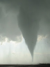
It's tough to trust anything in the NAM in the 00Z-06Z time frame given the convective explosion that is forecast. However, given the anticipated quality/depth of BL moisture, capping aloft that shouldn't be out of control (~7H temps not exceeding 8C), the added benefit of elevated terrain in the High Plains, and LLJ expected to accelerate to 40-50 kt after 00Z... it's realistic to expect a window of strong surface-based instability (MLCAPE 2000-3000 J/kg with very weak CINH) for a few hours after dark, coupled with 0-1 km SRH easily exceeding 300 m2/s2. Thus, if storms fire, potential exists for tornadic supercells and a strong tornado or two prior to 03-04Z. Mid- and high-level SR-flow is quite modest, but I can't help but be reminded of the loose analog case of 5-12-04... which featured modest flow aloft as well but had no trouble producing a dry-side-of-classic tornadic supercell.
Preliminary target = Allison, TX in far eastcentral portions of the panhandle. Haven't chased TX in three years!
Friday, April 24, 2009
Subscribe to:
Post Comments (Atom)

No comments:
Post a Comment