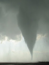
During the morning hours, an elongated shortwave trough tracked eastward thru KS-OK, supporting scattered thunderstorm activity. The airmass feeding into these storms was characterized by anomalously strong precipitable water values and effective parcels already rooted near the surface. A strong MCS was thus gradually born over the Red River valley, on the southern flank of the convective activity. The far western segment of the MCS outflow appeared to settle southwestward, and by early afternoon curved E-NE-N along a Crowell-Turkey-Wayside-Amarillo TX line (see 1945Z visible satellite image below). A second surface boundary was also evident on satellite, extending E-W from Crowell-Matador-Plainview and intersecting the dryline near Springlake. The latter E-W boundary was not apparent via the TX mesonet, but gradually appeared as a fineline of reflectivity on Lubbock's radar... its signature probably becoming blended with an increasingly well-defined RFD gustfront off the supercell-to-be. Also of note, a convergence line/surface trough was present in the moist sector a few counties east of the dryline, generally straddling the I-27 corridor.

A trailing shortwave trough, low-amplitude but well-defined in nature, approached west TX by mid-afternoon. Persistent isallobaric forcing, likely a result of both an upswing in QG ascent and increased heating of the outflow air, produced a well-defined low-level mass response along and east of the dryline between 21Z and 23Z. (See sfc obs below... no frontal analysis done as my usual analysis software doesn't have the TX mesonet data.) Enhanced downward mixing of westerly momentum forced the dryline eastward, where it merged with the convergence line near I-27; meanwhile, surface winds in the moist sector increased and backed substantially to the ESE. The supercell in question developed near the intersection of the E-W boundary and the effective dryline by 21Z, and tracked E to ESE along or just north of that boundary.

The Jayton profiler, located about 50 miles SE of where the storm became tornadic near Floydada, captured the mass response quite dramatically. Note in the 22Z and 00Z Jayton profiler hodographs below, the 500-1000 m flow backing and increasing to near 30 kt. Accordingly, given such a strong sr-inflow component and a perfectly kinked and curving hodo below 1 km... strong to very strong 0-1 km SRH resulted. Using the Plainview storm motion, 0-1 km SRH on the 00Z Jayton profiler was > 330 m2/s2 (with continued strong curvature through 3 km contributing to > 550 m2/s2 of 0-3 km SRH). Also note, 0-6 km bulk shear was moderate to strong, in excess of 50 kt. In comparison, the 00Z Amarillo RAOB hodograph (third hodograph below) showed 0-1 km SRH of ~200 m2/s2... though it's possible the strongest low-level mass response hadn't yet occurred by the time of balloon launch (~23Z) and/or occurred farther south only. With neither OFB evident in surface data and likely becoming increasingly diffuse given increased mixing/heating and mass response... it is tough to know whether or not the boundary enhanced horizontal vorticity available to the storm. Regardless, I would think the shear sampled by the 00Z Jayton profiler is a reasonable estimate for the Floydada area tornadoes, with any changes in the shear due to increased elevation on the caprock escarpment probably marginal.


The thermodynamic environment available to this storm was likewise very impressive, due to the influx of upper 60s surface dewpoints up onto the caprock combined with fairly modest capping aloft. In order to achieve the correct elevation/pressure surface for Floydada (which is a good 500 feet lower than AMA), I used a base NAM-WRF model sounding with a 900mb pressure surface (ideal given relative pressure surfaces in the region that evening) and applied the AMA RAOB data to it, blending the BL using TX mesonet data. The resulting dewpoint lapse rate is dry adiabatic (similar to that observed at AMA)... but this is known to happen when anomalously rich near-surface moisture exists. Bottom line, note the strong instability (MLCAPE > 3100 J/kg), very strong 0-3 km MLCAPE (~150 J/kg), and sufficiently low MLLCLs (1200 m). The second sounding below is the raw 00Z AMA RAOB, which likely got "munched" by anvil-level convection just above 200 mb.


In reviewing this data, it is probably a good thing for TX residents that the storm quickly became outflow dominant (with the gust front apparently undercutting the updraft and encouraging evolution to a small bow)... because the mesoscale environment was truly primed for strong to violent tornadoes. If I had been free to chase on this day, I hope that I woulda taken the chance on it.

No comments:
Post a Comment