
Similar to what happened the day prior (April 24), afternoon boundary layer moisture mixed out a good bit yesterday across far southwestern OK (see 23Z surface map below) in vicinity of the storms... with surface dewpoints falling to the 58-61F range. The 12Z NAM suggested this might be a problem... and BL trajectories emanating from the strongly/deeply mixed moist sector airmass around Childress/Wichita Falls didn't help any. While it appeared that more substantial moisture survived mixing and was lurking immediately to the east, that was not really the case... with the richest moisture being rather shallow on the 00Z OKC sounding (surface dews 64F but 100mb ML dews 60F)... not much improvement from the afternoon before. This was a far cry from what was forecast in previous model runs, and the "real-world" result was not surprising: high-based supercells amidst modest SRH before dark... transitioning to more low-based but increasingly elevated trash with diurnal cooling. Bottom line, by the time diurnal cooling/decoupling dramatically improved LCLs and SRH... the BL was probably too stable.

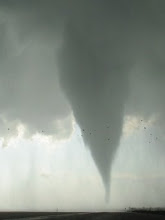
Interestingly, it appears that richer BL moisture pooled ahead of the quasistationary front from northcentral OK to northeastern KS, possibly due to less vigorous vertical mixing. This, combined with cooler thermal profiles through the low- and mid-troposphere, resulted in strongly surface-based environments but with far lower daytime LCLs than in SW OK. This may have been a factor in allowing a supercell to initiate on the front near Lawrence KS, move east a bit, and produce a beautiful 15-minute duration tornado in Leavenworth county around 630 PM. Another tornadic supercell moving off the front affected the Enid area of northcentral OK shortly after dark as well.
The 00Z Topeka RAOB (sounding #1 below) was launched just to the cool side of the quasistationary front and ~40 miles west of the Leavenworth co. storm. Given the shallow slope of the frontal system (frontal inversion only ~350 meters deep) topped by a moist layer/cap aloft almost identical to that observed in the warm sector well SSE on the SGF RAOB... it looked perfectly feasible to modify the Topeka RAOB to represent the Leavenworth co. tornado (sounding #2 below). Given relatively rich moisture just above the inversion, again the assumption is that somewhat richer moisture (ML dewpoints around 62F) survived mixing ahead of the front in comparison to in southwestern/southcentral OK. The modified Topeka sounding cranks out moderate instability with MLCAPE of 1689 J/kg; a strongly surface-based environment given MLCIN of 23 J/kg and 0-3 km MLCAPE of 59 J/kg; and favorably low MLLCL at 973 meters.


Hodograph #1 below is that observed on the 00Z Topeka RAOB; while hodograph #2 below shows the 22Z Lathrop MO wind profiler (in the warm sector ~60 miles ENE of the tornado). While near-surface winds backed slightly 22-00Z just ahead of the front, moreso than at Lathrop... the Lathrop profiler also showed more curvature through 1 km (~1 km flow more veered) than the warm sector RAOBs at SGF and OKC, which looked suspect. So it may be a wash... would estimate 0-1 km SRH of around 140 m2/s2 with 0-6 km bulk shear of 35 kt for the Leavenworth co. tornado. (Mid- and high-level sr flow was obviously pretty poor as well, though that didn't seem a major factor).


This was probably the 7th or 8th time I've been chasing well away from KC, only to have a semi-unexpected substantial tornado event occur close to home. Interestingly, it seems that many of these tricky far northeast KS-northwest MO "missed events" occur amidst shear environments that are not particularly impressive, with tornadoes probably occurring equally if not moreso due to processes associated with strong near-ground vertical stretching rather than low-level shear; the May 29 2004 Camden Point MO F3, June 4 2005 Hiawatha KS F2, and June 8 2005 Oskaloosa KS F0 come to mind, all of these being gorgeous (and in the former two cases, very strong) tornadoes. Mother nature likes to keep it interesting I guess, and I don't see that ever changing. Looking back at the model data from yesterday morning... I probably should have given the frontal boundary in that area a "closer look" with regard to chasing... esp since I was due back at work today.
Congrats to Dick and Darin for catching a gorgeous stovepipe tornado today not far from yesterday's action area... Roger Mills county OK. Sfc dews had no problem holding in the mid 60s today in the warm sector.

No comments:
Post a Comment